Hurricane Erin is due east of West Palm Beach now.
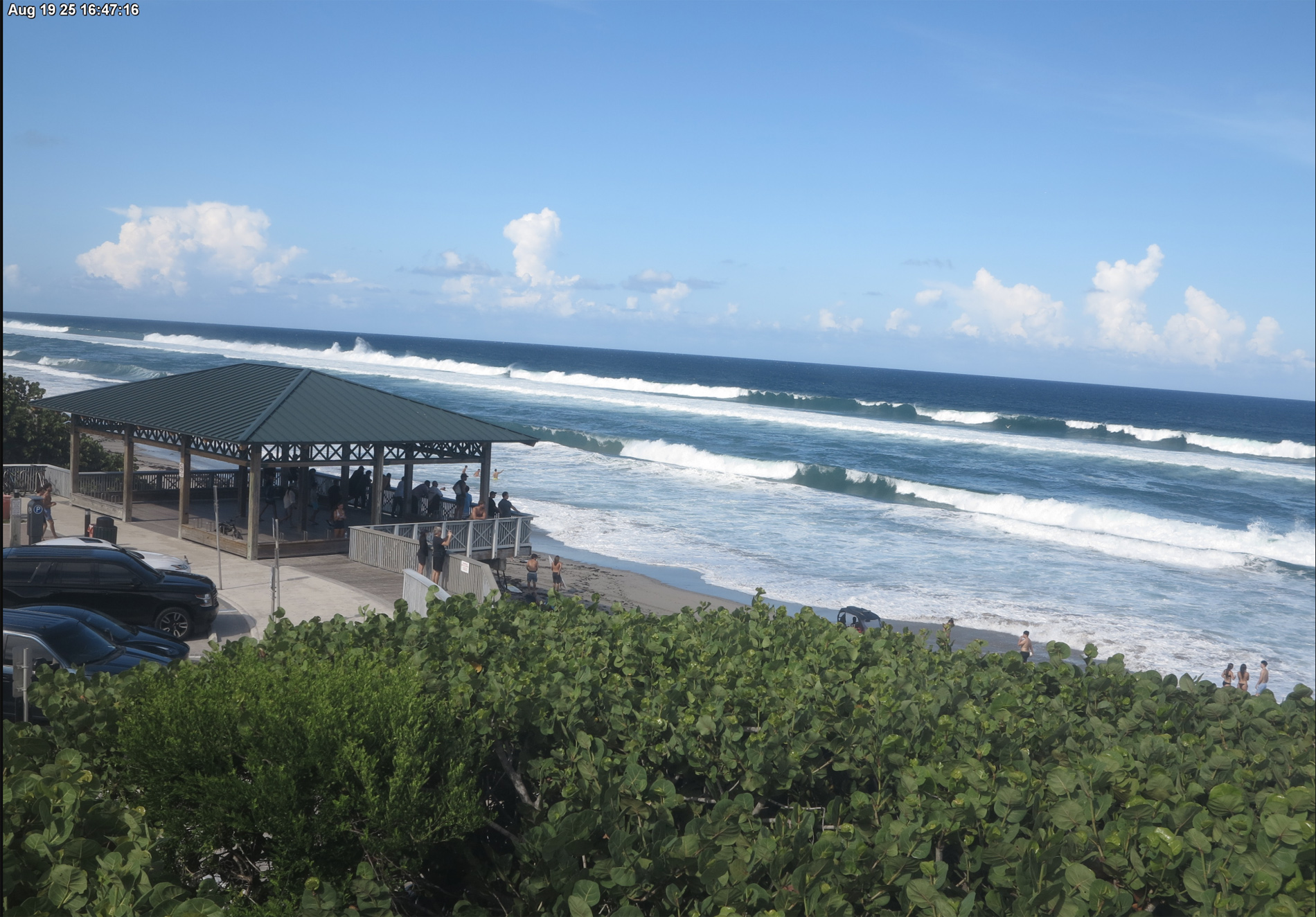
Giant closeouts this evening in Boca Raton. Not rideable.
Boca Raton, FL Palmetto Park Road Pavilion (South Beach Park).
Some waves either snuck through the Bahamas or they’re wrapping around the islands.
Interesting that this size at the same time is NOT hitting Palm Beach, Singer Island, Jupiter, and further north of Ft. Pierce.
Be careful out there. If you’re not a serious experienced surfer, don’t go in the water deeper than ankle deep. The currents, waves, and runouts are now extreme.
Inexperienced surfers should stay out of the surf too. I saw several surfers paddling out upcoast today and they had a “come-get-me-stroke.”
See the live beach webcams on my webpage on Brownie Bytes to see the surf and conditions:
8-17-2025 1 PM By R. Michael Brown, Writer and Multimedia Producer
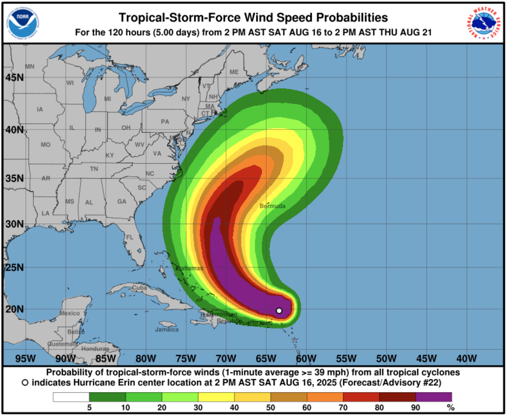
Windy Surf Forecast for Wednesday Afternoon 8/20/2025 at 4 PM.
Erin’s top winds have weakened, so the storm is now a Cat 3.
The National Hurricane Center is predicting that winds will increase to 145 mph in the next 24 hours making the storm a strong Cat. 4. They slowly decreasing after that. However, after the rapid intensification over the last 48 hours to a Cat. 5, the models still have difficulty predicting storm intensity.
Windy. As of this afternoon. is predicting really big surf in the 6′- 9′ range north of Palm Beach. Only big wave spots like Pump House, Reef Road, Monster Hole, RC’s will be able to handle a swell that size.
Most of Erin’s effects in Florida will be from Palm Beach County north. But, from the Windy wave forecast, it’s possible to get 5′ – 6′ in mid to southern Palm Beach County.
The wave window is Tuesday PM until Thursday PM.
Check on the current surf conditions with our FREE ‘Live’ Florida East Coast Beach Webcams here on BrownieBytes.net
Hurricane Erin strengthens into a Category 5, as it moves north in the Atlantic and experts warn of potential dangerous (and possibly) epic waves.
Swell-chasers and wary coastal property owners continue to monitor the trajectory, and strength of Hurricane Erin, as it continues toward the east coast.
Windy Peak South Florida Surf Forecast for Thursday, 8/21 at 7 AM
The storm is currently looming over the Caribbean, with a trajectory moving northward, with a path that curves away from the eastern seaboard, away from landfall, yet still sending stormy conditions (and potentially sizable swell) to the east coast.
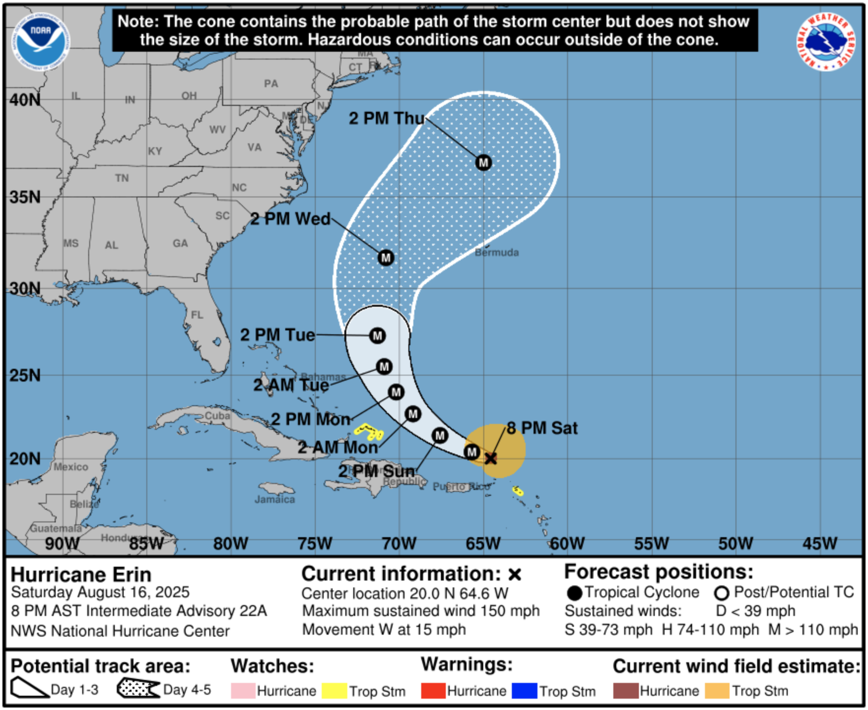
Hurricane Erin 8-16-2025 8PM Forecast
AccuWeather Lead Hurricane Expert Alex DaSilva, called the conditions “near perfect,” when it comes to the storm strengthening on its path.
“Erin is forecast to slowly curve to the north as it continues to strengthen over the weekend. At this time, the storm is forecast to remain hundreds of miles off the East Coast,” DaSilva said. When it comes to the waves, he continued:
“Beaches along the entire East Coast, from Florida to New England and Atlantic Canada, will likely experience rough surf and dangerous rip currents as Erin tracks north and eventually northeast.”
Here’s the latest from the reliable forecaster Bryan Norcross:
Norcross is known for his matter-of-fact content and delivery without all the hype from others that is intended to scare folks and get clicks.
Check on the current surf conditions with our Florida East Coast Beach Webcams here on BrownieBytes.net